Join JPI UE
Faq
FAQ
Please click here for the frequently asked questions we collected.
If you have an additional questions you are welcome to mail us at info@jpi-urbaneurope.eu
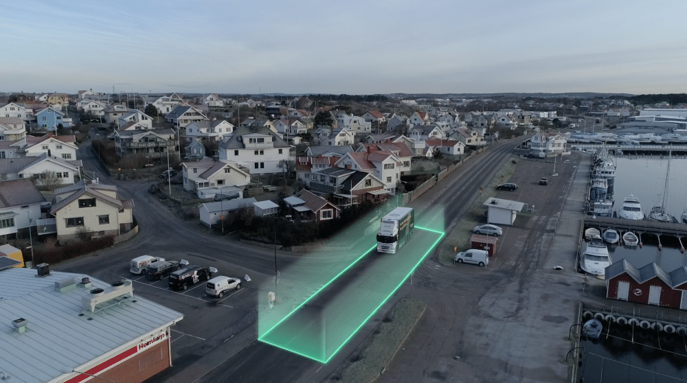
Photo: Lindholmen Science Park
Geofencing: A Virtual Fence for Real-World Challenges
At the heart of GeoSence lies geofencing, a location-based virtual fencing technology that triggers specific actions when a recipient, such as a mobile phone or vehicle, enters or exits a designated area. “Geofencing is a combination of technologies, primarily using GNSS (e.g., GPS) to create virtual location-based fences. When a recipient approaches a geofenced area, it triggers a specific action, such as providing information, warnings, or restrictions,” Rodrigue explains.
Rodrigue outlines five key steps for geofencing to work effectively. First, geographically bound information, such as traffic regulations and speed limits, must be available. Second, this information needs to be communicated from the data providers to the intended recipients. Third, the recipients, such as phones or vehicles, must be able to locate themselves geographically. Fourth, these devices can then act upon the received information, triggering warnings or restrictions. Finally, a feedback loop is necessary to ensure that the information has been received and acted upon correctly.
Protecting the Most Vulnerable
In Gothenburg, GeoSence took a proactive stance on enhancing the safety of vulnerable road users, such as the elderly, disabled, or young passengers, particularly in the context of special transport services. These services cater to the needs of the elderly, disabled, and young passengers, providing them with dedicated taxi-like transportation. The city had received feedback from parents and other stakeholders about instances of over speeding by the service providers, raising concerns about passenger safety.
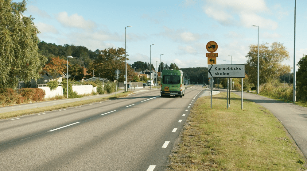
Special needs transport vehicle en route to school, where the speed limit is restricted to 30km/h.
To address this issue, GeoSence implemented informative and mandatory Intelligent Speed Assistance (ISA) using geofencing technology. The informative ISA displayed the current speed limit to the driver, while the mandatory ISA took control of the vehicle’s throttle, preventing the driver from accelerating beyond the set speed limit. When approaching a geofenced area with a lower speed limit, the mandatory ISA would restrict the vehicle’s speed, only allowing the driver to accelerate once the vehicle had slowed down to the new limit.
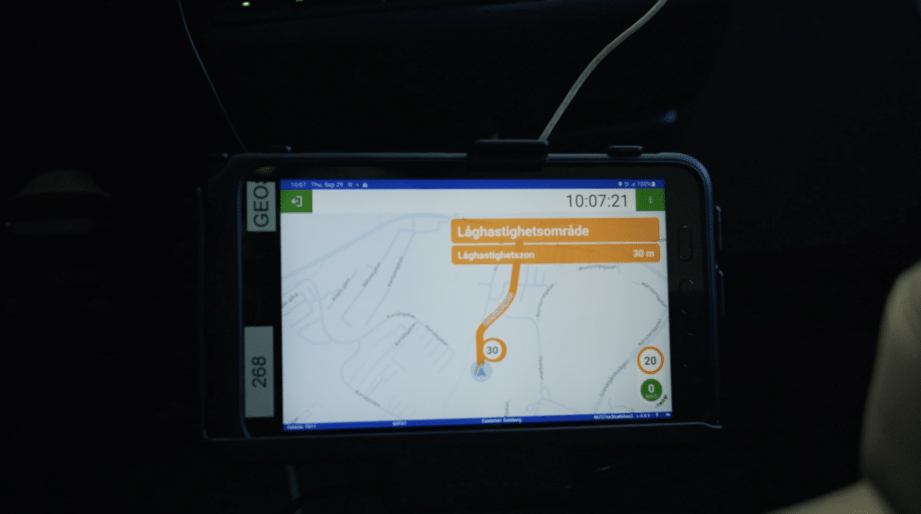
Screen indicating the vehicle is entering a speed-restricted zone. The screen is positioned for both the driver and passengers to observe as the vehicle enters a low-speed area. A film that explains the case more in depth: https://vimeo.com/775683705
The project had a pilot which aimed to reduce speeding in 23 designated low-speed zones around schools and elderly homes, ensuring a safer environment for these vulnerable groups. In this study, 18 special transport vehicles were retrofitted with a geofencing-compatible ISA system. The study provided promising results showing that the mandatory ISA technology had an impact on reducing over-speeding in the designated zones, with no case of a vehicle breaching the speed limit for more than a few seconds during deceleration, highlighting the potential for geofencing to create safer urban environments for those who need them the most.
However, the project also faced challenges in terms of driver acceptance and usability. “They were not against it, but they were perhaps not very clear that this will improve the situation,” Rodrigue explains. The study found that while the mandatory ISA had an effect on over-speeding, the informative ISA, which merely displayed the speed limit, did not significantly impact driver behaviour. This suggests that stronger interventions, such as directly influencing driving patterns, through automatic speed limitation, may be necessary to achieve the desired safety outcomes. Despite these challenges, the Gothenburg case study highlights the potential for geofencing-based systems to create safer urban environments for those who need them most.
Empowering Cities as Data Stewards
In Stockholm, the project delved into the city’s role as a data and service provider for geofencing solutions. The city government recognised the potential of geofencing technology to improve traffic management and road safety but wanted to ensure that they had the necessary data infrastructure and governance in place to support these applications.
Through workshops with internal stakeholders involved in the processes of generating traffic regulation data, as well as conducting a trial on a retrofitted ISA system installed in one of the municipal government’s own cars, the team sought to understand challenges and improve data quality and communication to road users. Preliminary results suggest that better synchronisation and communication with road users are needed. “The quality of traffic regulations data is not always the restricting factor; the communication of the data to the road user is equally important, and this is usually not controlled by the city,” Rodrigue points out.
The project also explored the potential for cities to enable more geofencing services, either by providing the data themselves or by allowing others to do so. Stockholm told the project that the city was not really interested in producing applications. Instead, the project’s workshops reinforced the idea that the city could effectively play a role as a data and service provider. “By empowering cities to become effective data stewards, GeoSence is paving the way for more responsive and data-driven urban mobility solutions,” Rodrigue explains.
Taming the E-Scooter Chaos
In Munich, GeoSence used geofencing technology to tackle the challenge of chaotic and haphazard e-scooter parking. The city currently has four separate e-scooter vendors and over 18,000 e-scooters, so parking has become a significant issue. To address this, the city implemented a dashboard to communicate designated parking zones to e-scooter providers and monitor parking behaviour in real time.
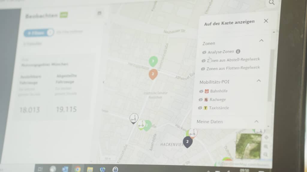
Additionally, information on parking and no-parking zones was also integrated into the apps for e-scooters. Combining physical parking space locations with digital geofences now helps to control and improve e-scooter parking because e-scooters can now only be parked within or near a geofenced parking area. Following this new use case, Munich saw significant improvements in e-scooter parking behaviour. “Before the regulation was introduced, the percentage of e-scooters parked in the vicinity of parking zones was just 19%,” Rodrigue reveals. He goes on to say, “when it was initially regulated, it went up to 71% in 2022; then when we started working with geofencing and improving it, it went up to almost 90% in 2023.”
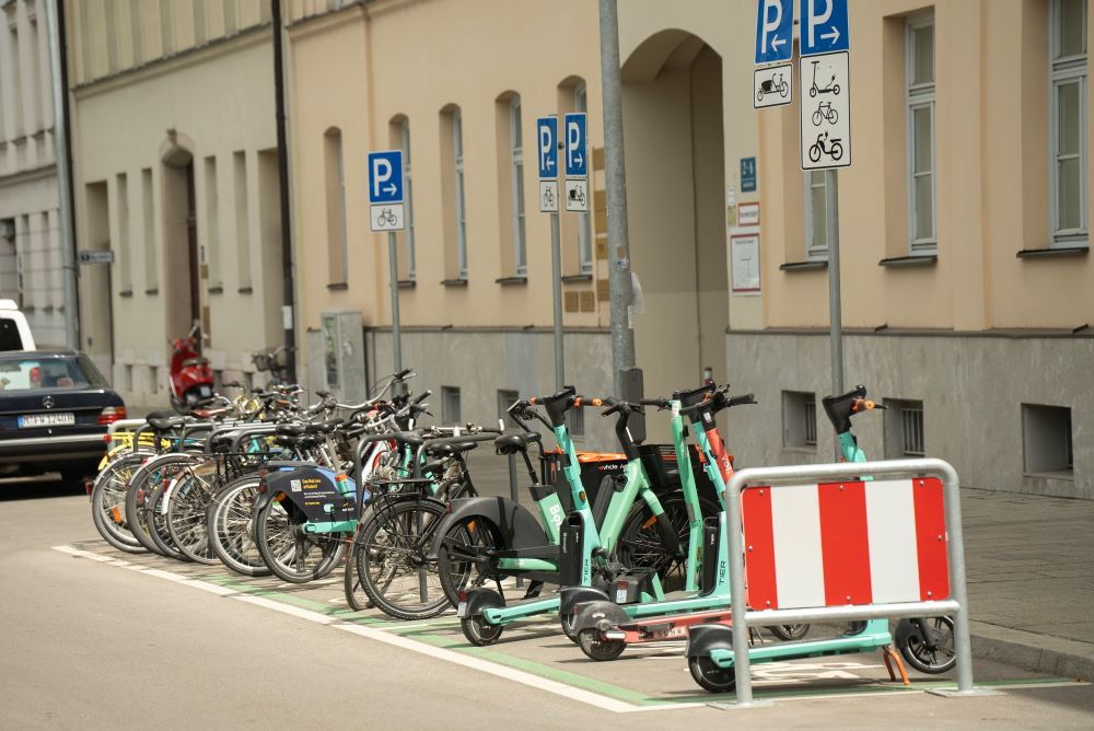
E-scooters parked within the restricted area that they can be parked in the Alt stadt in Munich.
Public perception surveys among pedestrians in the Old Town of Munich demonstrated that over 90% of respondents welcomed the regulation, with 53% of them being e-scooter users themselves. Rodrigue emphasises the importance of this collaborative approach taken by the city of Munich with e-scooter operators, stating, “this is a win-win situation; the city can get better insight into how e-scooters are parked, and they can try different solutions.”
However, the project also encountered challenges related to the accuracy and latency of the geofencing technology. “The instruments that we’re working with… they are not that fine-tuned,” Rodrigue explains. This is partly due to the low cost of the technology in a single scooter compared to a car. Nevertheless, he adds, “you have to work with good enough solutions.” Despite these limitations, the results demonstrate the potential for geofencing to bring order to the often chaotic world of micromobility. The key to regulating shared micromobility is not the infrastructure, but the digital control and, ultimately, the digital enforcement of the rules and good cooperation with the providers.
The Future of Urban Mobility: Collaboration and Innovation
As cities continue to face urban mobility challenges, initiatives like GeoSence offer a glimpse into a future where data-driven solutions and innovative partnerships pave the way for smarter, safer, and more sustainable cities. Rodrigue emphasises that this project has demonstrated the potential of geofencing technology in addressing various urban mobility challenges.
Looking ahead, Rodrigue believes that the success of GeoSence lies not only in the technology itself but also in the collaboration and knowledge-sharing between cities. By fostering collaboration between cities, technology providers, and researchers, the project has identified both the benefits and limitations of current geofencing solutions.
As technology continues to evolve, with improvements in accuracy and responsiveness, geofencing is poised to play an increasingly crucial role in shaping the future of urban mobility. With initiatives like GeoSence leading the way, cities can navigate the complexities of modern transportation, creating safer, more efficient, and more liveable urban environments for generations to come.