Join JPI UE
Faq
FAQ
Please click here for the frequently asked questions we collected.
If you have an additional questions you are welcome to mail us at info@jpi-urbaneurope.eu
City planners have to answer a tough question: should urban land be used to grow food, or should it be used to create renewable energy? In reality, they are being asked to do both at the same time. For example, in Germany, the government has already passed the Onshore Wind Energy Act, allocating 2% of the country’s land area to wind power. Yet, climate change and the war in Ukraine have also produced persuasive arguments for using urban land for food production to make cities more sustainable and resilient. To reconcile these two conflicting demands on urban land, the IN-SOURCE project has produced a data model that lets decision-makers assess development scenarios for providing food and energy instead of choosing between food or energy. One of the project’s key researchers, Volker Coors, tells us about how they did this and why their detailed 3D visualisation tools will be useful.
IN-SOURCE’s model (FEW CityGML ADE) was made to be widely applicable and easy to understand. It was created using the application domain extensions for an existing data model called CityGML. Volker explains that CityGML is already well-established in Europe as the standardised data form for 3D city modelling, so it made sense to build on it instead of starting from the ground up. Building its model using a data form that everyone is familiar with makes the learning curve for decision-makers much smaller. The base form of CityGML is normally used to simulate spatial designs for the built environment. However, with IN-SOURCE’s revised model, policymakers can now predict food, water and energy demand at the municipal level and simulate how productive and economically viable a municipality’s land assets would be in different future land use scenarios for food and energy production. A new feature of this model is that it can show decision-makers the potential outcomes of planning scenarios at different scales, such as the neighbourhood and regional scales. This will be useful in assessing which scenarios hold the most promise.
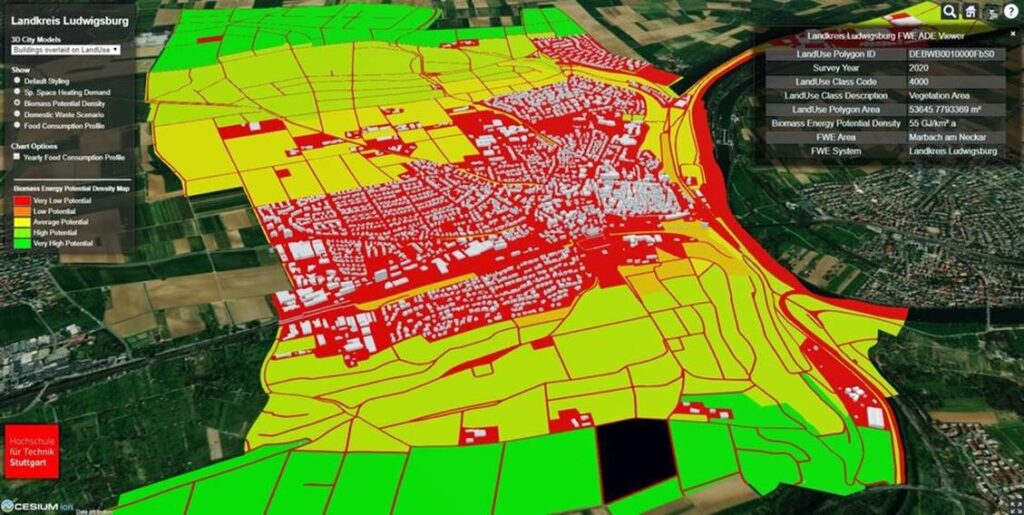
A new feature can show decision-makers the potential outcomes of planning scenarios at different scales, such as the neighbourhood and regional scales
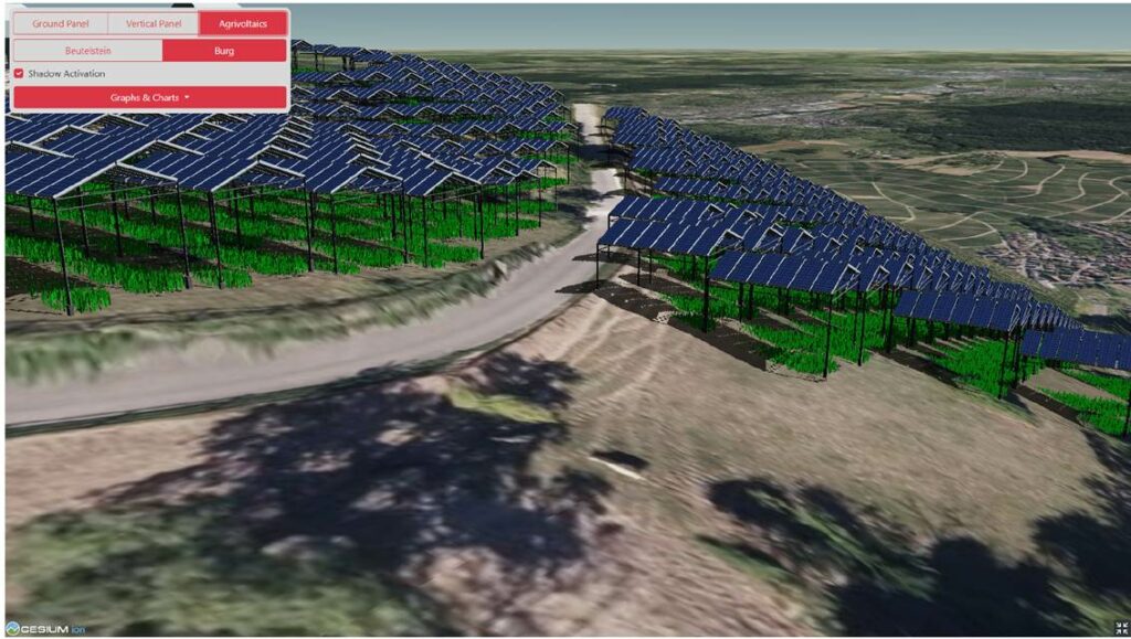
The project’s model has already shown policymakers in the county of Landkreis Ludwigsburg which land use scenarios are promising for generating renewable energy. The project created a simulation comparing four different land use scenarios for generating renewable energy using photovoltaic systems (PV). These systems use panels that directly convert the sun’s heat into electricity. The simulation found that the scenario using Agri-photovoltaic systems (APV), which mount photovoltaic panels above arable land, can cover 362% of Landkreis Ludwigsburg’s existing energy demand and 181% of its predicted energy demand for 2045, whilst accommodating food production. This finding is important as it shows decision-makers that it is possible to find solutions that tackle food demand and energy requirements at the same time. Volker is careful to add, “of course an APV system would impact the kind of crop you could use on the land below it because it creates shadows and is a little bit less efficient for food production, but it looks like a very good compromise as it allows for both.”
The project also uncovered an unexpected synergy between roof-based PV systems and urban roof greening. The project’s researchers had predicted that green rooftops would be detrimental to PV systems, as they expected plant material would obscure the photovoltaic panels, decreasing their efficiency. Yet, their simulation work shows combing roof greening with PV is technically feasible and slightly increases power generation.
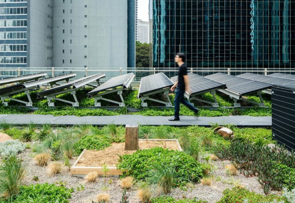
Their results show roof greening had a cooling effect on the PV panels which made them more efficient, increasing photovoltaic yields by 0.3%, decreasing space heating demand by 0.1%, and reducing rainwater runoff by 30%. Unfortunately, the simulation also showed that combining rooftop greening with PV is currently an economically unviable strategy, since “only around 31% of the initial investment [in the system] can be recurred over the assets’ [PV system’s] lifetime.” Volker argues since energy prices have changed substantially since their work was done, its sustainability should be reconsidered. This could be an opportunity for policy-makers across the world.
Roof greening had a cooling effect on the PV panels which made them more efficient, increasing photovoltaic yields, decreasing space heating demand and reducing rainwater runoff.
Another key outcome from the project is an innovative method for accurately simulating the stress urban water demand puts on local resources. This will allow decision-makers to plan sophisticated water provisions policies that account for the variation in their city’s building stock. This method has already been used to produce water demand figures for the city of Cologne and the counties of Landkreis Ludwigsburg and Ilm-Kreis. Although there are already a number of existing tools and methods for calculating urban water demand, IN-SOURCE’s method has two potentially ground-breaking features: their model can simulate water demand down to the scale of a single building as well as the regional level without losing any detail. Furthermore, arguably this is the first water demand simulation tool that can account for all building types. So, policy-makers can use one tool instead of many. This was done for the three case study areas mentioned above, producing urban water demand figures for residential buildings, non-residential buildings and industrial buildings.
Potentially the most important project outcome from a stakeholder engagement perspective is the creation of the Vistoolbox. Within the Vistoolbox, users can use the CityGML model to generate a 3D rendering of a neighbourhood, town, city or even a municipal region, depicting food, heat, and water demand for every individual building. Volker says, “this produces a better understanding of what could happen in a short period of time.”
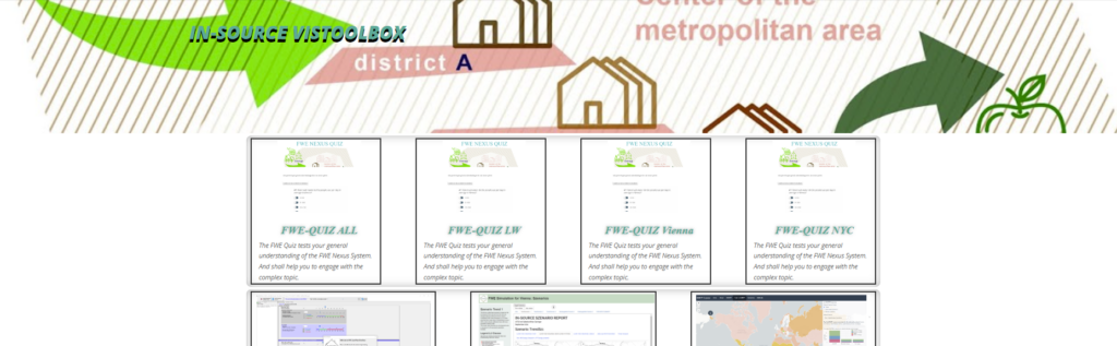
In the long-term, the Vistoolbox could have a great impact on communicating with the public about complex land use scenarios and gaining their support for land development scenarios. The toolbox is already being used in the town of Weinstadt to create visualisations to decide between two potential locations for a potential solar park. These visualisations will allow Weinstadt’s citizens to give more feedback on how they feel about the different options as well as offering policymakers an indication of which plan has more public support, resulting in a more democratic decision-making process.
“policymakers and citizens have to come together to decide on their priorities.”
In the end, the IN-SOURCE project has managed to produce a data model that help decision-makers answer the question of whether they should use urban land for food production or renewable energy. However, Volker stresses that although their work has done a great job at identifying where these conflicts exist and how urban land performs in different scenarios, it does not entirely resolve the conflict as “policymakers and citizens have to come together to decide on their priorities.”