Join JPI UE
Faq
FAQ
Please click here for the frequently asked questions we collected.
If you have an additional questions you are welcome to mail us at info@jpi-urbaneurope.eu
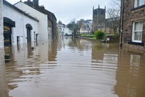
As sea levels rise and the battle against flooding intensifies, households will have to prepare. The problem is particularly stark for people living in low-lying regions. In a high-risk place like Llanrwst in Wales, residents feel compelled to set up their own flood action groups. They think their local government is not doing enough to protect them. You can find similar stories across Europe; another example is Venice, where locals also complain about ‘being left to their own devices’. However, on a household level, people have little idea how to protect themselves. The project FLOODLABEL offers a solution to this problem. It has created a smart and simple app which lets individuals assess their home’s exposure to flood risks, and it offers tailored advice about what they can do to reduce these risks and protect themselves. In this interview, Patrick Witte, the project’s coordinator, explains how it all works.
Public awareness in the age of climate change
Patrick highlights that even though climate change is on the news almost every day, there is very little public understanding of flood risks and flood mitigation techniques. Even in the Netherlands, a country famous for its strong flood defence systems, the general public has little understanding of how flood defences actually work. In the Dutch case, the government competently prevents flooding all the time. So, on an individual level, people haven’t given this issue much thought.
However, Patrick believes that climate change is having such a profound impact on flooding that even the Dutch government will struggle in the future. He reasons, “the extremes are becoming more extreme, and the government may not be as technically nor financially in a position to care for their people to the fullest extent.” So, if government capabilities are reduced, citizens will be forced to protect themselves. This motivated the FLOODLABEL researchers to provide a flood assessment tool for ordinary people. They wanted to give people the opportunity to assess their own flood risk exposure and make them aware of the measures they could take. This system had to be both accessible and simple to use. Additionally, it had to feel intuitive and familiar.
Inspired by washing machines and toasters
Unfortunately, existing systems were too complicated for ordinary people, so they decided to build a new one. Patrick supports this argument by explaining how existing assessment systems work. He talks about the German forerunner project to FLOODLABEL, HochwasserPass. He says, “our colleagues ran this project using existing methods; these methods involve water engineers visiting someone’s home, using questionnaires, and assessing specific building characteristics.”
Ordinary household appliances, like toasters and washing machines, became an important source of inspiration for the team. More accurately, the EU energy labels found on these appliances gave them a lot to think about. Patrick reminds us that almost everyone is familiar with these labels. The team reflected on how these labels motivate behaviour. For example, when people buy a washing machine, they probably won’t get one with a terrible energy label; they know in the long run this costs them more money. Patrick recalls, “we asked ourselves, could come up with something similar for floods?” The answer was yes.
You don’t need an ark but you could use an app
The project currently has a prototype flood risk assessment app with a lot of potential. At the moment it’s a simple web app, but they aim to refine it into a sophisticated mass usage product. Using just a property’s postcode and a short questionnaire, the app can already produce a general flood risk label within minutes. However, that’s just the first step. It can also create a more refined label by showing you a “schematic of your house and the type of measures you can install.” Indicating which of these measures you have or don’t have offers an even more precise label. Patrick is very pleased about what they’ve achieved so far.
However, he’s also keen to emphasise that they are still testing the app and need to refine the labels further. He wants us to understand that flooding is a very complex phenomenon. He describes how there are actually four different types of flooding: river flooding, heavy rainfall flooding, ground water flooding, and sewage flooding. Therefore, the project’s labelling system has to reflect this. This is why the label is aggregated from “a combination of a few sub-labels.” These sub-labels offer a grade for each type of flooding. This helps users understand which kind of flooding poses the most risk for their property.
Technology doesn’t work without human engagement
Although Patrick is very happy about what they’ve achieved, the project confirmed to him that there will always be a need for experts. He believes the app is currently too general and needs continual expert input to validate it. He argues, “without an expert precisely assessing a house in their local contextual environment, many proper measures can’t be implemented.” However, the app’s general labelling could lead experts to focus their resources on the properties that need their input the most.
“Patrick insists their success with the app was very dependent on having good communication with key stakeholders.
He talks fondly about the positive experience of working with the municipalities of Dordrecht, Zwolle and Venlo.”
He also mentions their close working relationship with the waterschappen (regional water boards responsible for managing water systems in a specific area). He’s particularly thankful to the households who offered them the input necessary to create the app.
A Flood Risk Map for the Future
Reflecting on what the project’s results mean for the future, Patrick shares some exciting ideas. First, he discusses the advantages of working on a European level: they now have data in different countries facing different flooding problems. He offers an example, “our colleagues in Austria have avalanches to consider, and I don’t have so much experience with this.” He thinks having this kind of data makes their model much more widely applicable and capable of producing holistic labels.
Patrick finishes the interview on an idea he’s particularly excited about: making the results of the project useful on a governance level and not just on a household level. If the app is rolled out and they can get mass usage, in theory, they could provide a GIS map for municipalities. This map would clearly show which areas are most at risk from flooding. He says:
“We plan to already make the first steps in developing this within the project, we do have a really rough prototype of a dashboard,
where the municipality or a water board can review, on a neighbourhood scale, the labels on the houses.”
This would allow them to take action on a scale which isn’t possible for individuals. Perhaps, if individuals use this labelling system, even in the future governments might still be able to fight flooding competently.