Join JPI UE
Faq
FAQ
Please click here for the frequently asked questions we collected.
If you have an additional questions you are welcome to mail us at info@jpi-urbaneurope.eu
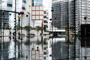
Creating a flood risk assessment tool requires complex insight into user engagement as well as the right and relevant data. The FLOODLABEL project has successfully created a prototype flood risk assessment and mitigation app designed for the ordinary homeowner. It creates a base for the development of a system to create more resilience/awareness that could also save governments millions of euros in the long term. Nelen and Schuurman is one of the handful of companies who picked up the task of building the app, with expertise in both IT services and water management. Jelle Degen from their FLOODLABEL team is happy to talk to us about how they built the app and what they learned from the project.
Defining the end user
Nelen and Schuurman were particularly suitable as project partners, because their knowledge in both water management and developing IT. Jelle explained that “having both the knowledge about water and creating information services, was a great addition to the knowledge in the consortium.”
Although Jelle’s focus was on the technical side of the project, he was still very concerned about user engagement. He argues, developing a tool is not easy if you don’t have a clear picture of your user. This posed a challenge at the beginning of the project as FLOODLABEL aimed to create a tool for both homeowners, expert users, and policy makers. This is fine as a long-term goal, but in the short term you cannot build an app that works for all groups. In the end, they settled on focusing on homeowners, which meant the interface of the app was carefully tailored to their needs and interaction patterns.
However, choosing a specific target group to start with doesn’t mean a project has to abandon its long-term goal. On the contrary, Jelle argues:
“If you can successfully reach one group of people,
you take the same data and build a tool for another group more easily.”
As long as the data is rich and relevant, it can be used again with a different aim and level of complexity.
The future of FLOODLABEL
Now that the project has developed a successful prototype, Jelle thinks there are three technical areas to work on to make a more effective final product. The first is to use more high-resolution maps and data. Including more details would mean the flood labels would be even more precise, as the boundaries between properties, buildings and flood routes would be even clearer.
The second thing Jelle would like to see is more user input options, because not all relevant data is available. He gives an example, “now, we calculate the potential water level for each building, but we don’t take into account where the front door is located, or whether there is an elevated entrance” The location of the door and height of the entrance, of course, changes the risk of flooding damage. So, getting users to submit data about household features like this could make a real difference to household safety.
Lastly, Jelle thinks FLOODLABEL could be refined to make more sophisticated calculations. Currently, the app asks simple questions like, “are there flood barriers around the house?” This question is mostly relevant to river flooding risks. Although the app does distinguish between these types of flooding, Jelle reminds us that the likelihood you will encounter a particular kind of flooding is highly dependent on your local environment. He believes the app could be refined to calculate risk with more precise weighting given to local conditions.
“Both the method and system are generic enough to be scaled up
and used in many places that suffer from flood risks.”
Outcomes
Despite the scope for improvement, Jelle believes they have achieved a lot. Both the method and system are generic enough to be scaled up and used in many places that suffer from flood risks. Coming back to the goal of creating a tool for policy makers, Jelle notes “all the back-end data is ready for use when we want to make that second interface for policy makers. A good example of such a tool focusing on policy makers is Bluelabel” So, there is clearly still a lot that could be potentially be done. Jelle is confident creating a dashboard for policy makers which keeps an overview of flood risks is achievable. Overall, Jelle and his team have learnt a lot from the academic partners about the different approaches in language and style that have to be deployment when talking to diverse groups like homeowners and policy makers.